GeoTag Tool
A free browser tool for writing GPS coordinates, keywords and a description into a photo's metadata, then downloading a tagged copy. No account and no upload.
 GT
Project links
Visit productRequest correctionProject Note
A closer look at GeoTag Tool
A free browser tool for adding GPS coordinates, keywords and a description to the metadata of JPG, PNG, WebP and HEIC photos.
Putting a location on a photo
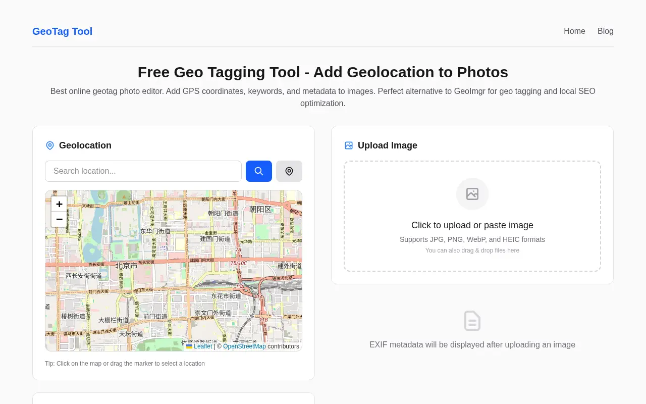
Some photos come out of the camera without location data, and some need a different location than the one recorded. GeoTag Tool handles that on one page. You upload or paste an image, and the page shows the photo's existing EXIF data once it's loaded. Then you set the location by searching for a place, clicking the map, dragging the marker or using your current position.
You can also add up to 6,600 characters of keywords and a 1,300-character description, then download the result. It takes JPG, PNG, WebP and HEIC photos.
A fresh copy, and a tip about formats
The original file isn't touched. The tool saves a new copy with "_geotagged" added to the filename. For the most reliable result the site recommends JPEG, since JPEG stores EXIF natively, while PNG metadata isn't read the same way by every app and can be lost in format conversions.
It's useful for a photographer adding locations to a portfolio, someone sorting travel photos, or a small business tagging images of its premises. The site leans hard on local SEO, saying geotags help a business show up in local search and on Google Business Profile. That's the site's own claim, and its pages don't point to any evidence for it, so treat it as a hope rather than a feature.
Before you tag your first photo
The tool is free, with no account, no usage limits and no watermark. According to its FAQ, all processing happens in the browser and no images are uploaded to any server. The page loads no upload service, only the tool's own code and Umami, a cookie-free analytics script.
There's no privacy policy page, though, and nothing on the site names who runs it. It lives on a subdomain of ccwu.cc, with a support address on the same domain. If you've got a folder of travel photos with no location attached, it's a quick thing to try on one of them.
For reference
Project facts
The published details and source context, together in one place.
- Stage
- Launched
- Public Context Check
- Public pages were checked Nov 9, 2026.
Project note details
Dates and editorial links
Published
November 9, 2026
Updated
November 12, 2026
Note history
Publication and substantive update dates for this public note.
- Nov 9, 2026
- Project note published.
- Nov 12, 2026
- Project note updated.
- Nov 9, 2026
- Public-page information added to the note.
Want to come back to GeoTag Tool?
Save it to this browser. Your Saved list marks projects whose note or updates changed since you last looked.
Keep exploring
More like GeoTag Tool
- SumivoUtilities & Calculators · 48 free calculators for batteries, circuits, OEE, takt time, fractions and more, each with its method and test runs shown.
- metadata.videoUtilities & Calculators · A free metadata viewer, editor and remover for video and photo files.
- PanelOSUtilities & Calculators · A Windows app that puts live PC stats, a clock, weather and now-playing info on a 3.5-inch USB case screen.
- MortmeterUtilities & Calculators · A free site that prices any activity by the odds it kills you, then turns that into time off your life at your age.
- Concrete CalculatorUtilities & Calculators · A free concrete estimator that turns your measurements into cubic yards, a bag count and an optional material cost, with no account.
- WatchToTextUtilities & Calculators · A free tool that turns a public YouTube link into a transcript you can copy or download as TXT, SRT or VTT.
- HouseRulerUtilities & Calculators · HouseRuler is a free 7th house ruler calculator for people learning relationship astrology, with written interpretations for each house placement and a paid personalised report.
- LizelyUtilities & Calculators · Lizely is a free collection of browser tools for PDFs, images, text and code.




For the makerAdd the badge to your site
If you made GeoTag Tool, you can post about this note with a ready-to-edit announcement, or show it on your own site with an optional badge that links back here. Neither has any effect on the note or its placement.
Want to keep this note's facts current yourself? Project Radar Pro lets a verified maker confirm status, pricing and platforms in a labeled block, post one update a month and see the note's activity totals. It never changes the note's text or placement. See what Pro includes
Building something useful?
Submit your project for free. If selected, it gets a Project Note that explains what it does and links to your work. Publication isn't guaranteed.
Submit a project