
Project links
Visit productRequest correctionProject Note
A closer look at ArgenFields
ArgenFields is a map and listings site for farmland in Argentina and the US that builds a technical sheet for any parcel from public soil, climate and cadastre data.
Reading the land before the visit
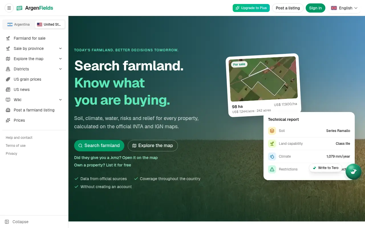
Buying farmland usually starts with a listing that tells you the price and the hectares and very little about the ground. ArgenFields, a map and listings site for farmland in Argentina and the US, tries to fill that in from public records. Its home page example is a 98 hectare field at US$17,900 a hectare, shown with a technical sheet: the soil series, a land-use capability class, 1,079 mm of rain a year and no restrictions detected.
The process is four steps. You search for a district or town, then switch on map layers such as soil, climate and water. Relief and cadastre layers are there too. Tap a parcel to calculate its sheet, then put two fields side by side to see how they differ. If someone has sent you a boundary file, the map opens KML, KMZ and GeoJSON, or you can draw the perimeter by hand.
How far to trust the sheet
Soil, climate, relief and cadastre data come from public sources, and the site names Argentina's INTA and IGN and provincial bodies. It's direct about the limits. The data is indicative. It helps compare fields and rule options out quickly, and it doesn't replace a soil study on the lot or walking the field. The help page adds that where no survey map exists the site says so instead of filling the gap with an average.
The team behind ArgenFields is just as plain about scope. They say mapped coverage varies by location and source, and that the indicators support early research and don't replace an on-site study, a professional appraisal or a title review.
The terms draw a firm line around the listings too. ArgenFields publishes them. It isn't a real estate agency or a broker, doesn't take part in the negotiation and charges no commission on a sale. Contact between the person listing and the person searching is direct. It also states that it doesn't verify the ownership of listed fields, the accuracy of the price or the improvements a seller declares. Treat a listing as a lead to check, the same as anywhere else.
Before you sign up
Looking at the map, sheets, zones and wiki needs no account. Listing a field, saving favourites or buying a plan does. On price, the team says the map, regional pages and soil wiki are free, full field reports have a weekly allowance on the free plan, and paid plans add report capacity for people researching several fields.
In practice, the full technical sheet on the free plan is limited to one field a week. In Latin America, Plus costs $9 a month or $79 a year and Pro costs $29 a month or $259 a year, with analytics for your own listings. Elsewhere the help page gives $19 and $49 a month.
The privacy policy, updated November 8, 2026, says it describes what the site does with your data and was written against the code. Traffic is measured with Google Analytics, which uses two cookies. Photos are re-encoded before they're stored, which strips the GPS location a phone camera writes into the file. The contact is given as Team ArgenFields, and no legal entity is named.
If you're weighing up a field and want the soil and rainfall picture before you drive out to see it, the free map is a sensible place to start.
In their words
From the team behind ArgenFields
“Indicators support early research and do not replace an on-site study, professional appraisal or title review.”
“The map, regional pages and soil wiki are free.”
For reference
Project facts
The published details and source context, together in one place.
- Stage
- Public launch
Project note details
Dates and editorial links
Published
November 10, 2026
Updated
November 12, 2026
Note history
Publication and substantive update dates for this public note.
- Nov 10, 2026
- Project note published.
- Nov 12, 2026
- Project note updated.
Want to come back to ArgenFields?
Save it to this browser. Your Saved list marks projects whose note or updates changed since you last looked.
Keep exploring
More like ArgenFields
- BskyDeleteSaaS · BskyDelete lets Bluesky users filter, review, export and bulk-delete posts, likes and reposts, and clean their following list, through official OAuth.
- Ground ControlSaaS · Order property lists by area and estimated features, or add property details to an existing address list.
- TiquoSaaS · Hospitality software for hotels, restaurants, spas and clubs that combines point of sale, bookings, payments, memberships and customer records.
- VoiceFleetSaaS · VoiceFleet is an AI inbound voice receptionist that answers business calls, handles FAQs, captures messages and books appointments using configured instructions.
- DeleteThreadsSaaS · DeleteThreads bulk-deletes Threads posts, replies, quotes and reposts through official OAuth, with filters, schedules and a deletion queue that respects daily limits.
- PDF to AudiobookSaaS · Convert English text PDFs into chapter MP3s with preset AI voices.
- PDF Annotation RemoverSaaS · Remove PDF highlights, sticky notes and markup locally in your browser.
- TruckerFetchSaaS · A U.S. carrier research tool built on FMCSA records.





For the makerAdd the badge to your site
If you made ArgenFields, you can post about this note with a ready-to-edit announcement, or show it on your own site with an optional badge that links back here. Neither has any effect on the note or its placement.
Want to keep this note's facts current yourself? Project Radar Pro lets a verified maker confirm status, pricing and platforms in a labeled block, post one update a month and see the note's activity totals. It never changes the note's text or placement. See what Pro includes
Building something useful?
Submit your project for free. If selected, it gets a Project Note that explains what it does and links to your work. Publication isn't guaranteed.
Submit a project